OP
What Are You Doing Right Now? (1,433 Viewers)
- Thread starter ßöмßäяðîëя
- Start date
- Tags gay space iliveforfinasteride iliveforjuve is not white loldevil size queens sweet matt is sweet errwhere virgin devil
More options
Who Replied?


Fuck_my_mother.
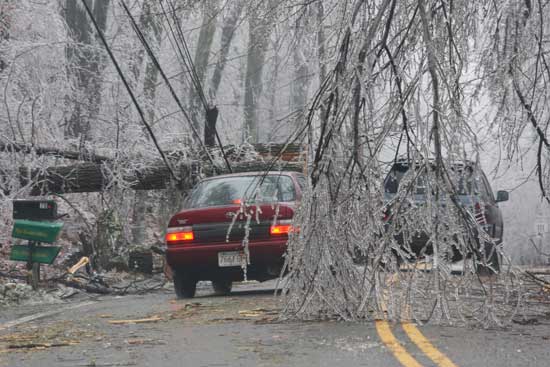
This is a seriously bad ice storm on the way. The center of the low will pass right over the Northern Mid-Atlantic and it appears we will be below freezing for the duration of the event. We're talking an inch of ice looking at the short-term NAM model here.
I wouldn't be surprised to be without power for a couple days after this storm. I'm hoping not as much warm air overrides the area so that the precip type can remain as sleet, but that very rarely happens in these sort of events around here.
Lots of structural damage on the way as well.
Couple days without power? :O
Philly will see a lot of freezing rain and sleet, but you may change over to plain rain on Wednesday. My area -- not so lucky.

OP
Burkey, would you tap his widow?
Fuck_my_mother.
This is a seriously bad ice storm on the way. The center of the low will pass right over the Northern Mid-Atlantic and it appears we will be below freezing for the duration of the event. We're talking an inch of ice looking at the short-term NAM model here.
I wouldn't be surprised to be without power for a couple days after this storm. I'm hoping not as much warm air overrides the area so that the precip type can remain as sleet, but that very rarely happens in these sort of events around here.
Lots of structural damage on the way as well.
Couple days without power? :O
Already got a dusting of snow. More on the way before it changes to freezing rain sometime tomorrow midday.
...and how bad?
ßöмßäяðîëя;2874116 said:
Hell, I would tap his body now...
When is it going to start for me?
Silliness, yo, straight silly.
WHEN IS IT GOING TO START FOR ME?
...and how bad?
When is it going to start for me?
Silliness, yo, straight silly.
WHEN IS IT GOING TO START FOR ME?
...and how bad?
Starts for you between 6 and noon tomorrow.
Bjerknes, whats this I hear about a blizzard in chicago?
Enjoy it, Deneb.

OP
It depends on how much warm air works into your area, both at the surface and wedging ~1km up into the atmosphere. Chances are you'll stay colder than predicted at the surface and have more warm air advection further up than we will, so you'll probably have mostly freezing rain, little sleet. That's bad news. You may get around a half inch of freezing rain accumulation, which means you have a good chance of power failure issues. The heaviest precip in the core of the storm will be North of you, in my view. Depending on the track, if the low moves more North than thought, you may get above freezing for longer on Wednesday and that would be good news. So because of this I'm thinking the jackpot for ice accumulation will be Southern PA, right in my fucking goddamn asshole.
Starts for you between 6 and noon tomorrow.
Starts for you between 6 and noon tomorrow.
Yeah, it's going to be insane up there, very jealous of what they'll receive. They are actually in the midst of a very complex situation where they are on the backend of a low pressure system heading Northeast from the Southern states that will contain a lot of Gulf moisture with it. But the storm will be so intense that it will whip up winds originating from the North, slamming into Chicago over Lake Michigan, thus creating a Lake Effect Snow enhancement. So basically, the Chi will have snow coming at them from all angles. A perfect storm for blizzard conditions.
Enjoy it, Deneb.
Enjoy it, Deneb.
 I'm in chicago right now